LAB Pro
Can Tho, the fourth-largest city in Vietnam, experiences significant flooding each year. A master plan is being developed for the Can Tho University campus, located in the city centre, with the goal of promoting sustainability, preserving the green environment, and protecting the area from stormwater flooding through Nature-Based Solutions (NbS). As part of this effort, NbS will be planned and implemented in the park on the campus, to serve as a foundation for integrating them into the master plan for the entire campus.
Authors: Jaakko Heinonen & Paul Carroll
Nature-Based Solutions
Although urban greening and the use of water elements for various purposes has been around for much longer, their use formerly was not systematic or clearly defined as solutions for flood control, with aesthetic aspects being more emphasised. The concept and use of the term Nature-Based Solutions (NbS) in urban planning is relatively new. Starting in the 2010s and expanding through to the 2020s, they have developed from alternative methods to mainstream ones. The central formal definition by the International Union for Conservation of Nature for NbS is ”actions to protect, sustainably manage, and restore natural or modified ecosystems that address societal challenges effectively and adaptively, simultaneously providing human well-being and biodiversity benefits.” (Cohen-Shacham et al. 2016).
The following NbS can be used by themselves or combined and bring multiple benefits to suitable locations. Bioretention systems are landscaped depressions with vegetation, where water can gather. Vegetative swales and rain gardens are smaller-scale examples of these, often located in residential areas. Green or vegetated roofs have both stormwater retention properties and other benefits. Permeable pavements avoid water gathering in streets or parking areas.
The central solution used in the research site here, and one suited to a larger scale area, is that of a floodable park. These are situated, as in this case, in a low-lying recreational area and have the specific feature that the water level in them can vary over different periods, and even during times of flooding, the park itself can still be partially used for leisure purposes. As well as dealing with heavy rainfall incidents by detaining runoff, floodable parks can help to enhance water quality and recharge aquifers (Munoz et al. 2024).
Can Tho University Campus
The flood vulnerability of Can Tho, a city criss-crossed by numerous rivers and canals, is affected by several factors. Rapid urbanization has left little permeable surface in the city (Image 1). In the Ninh Kieu area, where the university campus is located, the population density reaches 9200 inhabitants per square kilometre. The city’s low elevation (at only 0.6–1.2 metres above sea level), rising sea levels due to climate change, tidal fluctuations, and land subsidence of 4 cm per year approx. caused by groundwater over-exploitation, further increase the flood risk. Flooding occurs due to extreme rainfall, tidal changes, river flooding, or their combinations. (Behre et al. 2020; Ty et al. 2021)
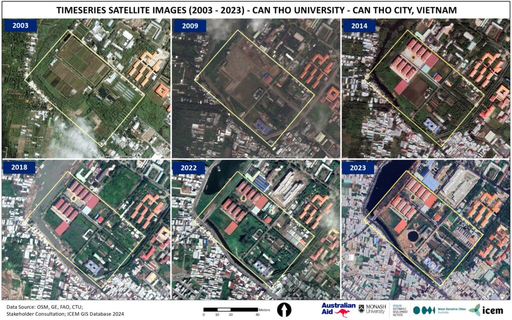
Image 1. Changes in the environment around Lake Bung Sang and Can Tho University Campus, including the study area, from 2003 to 2023. (Image: Vinh 2023)
Stormwater runoff from the campus is discharged into the nearby Lake Bung Xang via stormwater drains and channels. If the lake’s water level rises due to flooding or unusually high tides, discharge routes will be closed to prevent water from entering and flooding the campus. In cases of simultaneous heavy rainfall, the campus must be able to detain the runoff within its area.
Floodable park design and hydrological modelling in flood assessment
In his master’s thesis Heinonen (2025) examined the potential for detaining and storing runoff generated by various present-day and future extreme short-term rainfall scenarios within the park area of focus. The study assessed precipitation, runoff volume, and runoff flow time from the park’s catchment area in a scenario where the discharge routes to the receiving lake were closed.
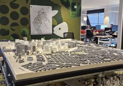
Two different park design drafts were developed, based on the previously proposed park pilot design from the Resilient Urban Centres and Surrounds (RUCaS) programme (WSCA and ICEM 2024). Park designs were considered as floodable parks. This NbS approach enables extensive controlled flooding and park ponding, which is where water accumulates on the surface after heavy rain.
Hydrological rainfall-runoff models were created for the current situation of the park (see article illustration) and the proposed park design drafts using the SWMM (Stormwater Management Model) software to estimate the maximum precipitation that the park and its catchment area could detain. Possible future land use and the intensification of rain events caused by climate change were considered in the modelling. The study revealed that the most effective way to detain and store runoff within the park is by maximising flood storage capacity, allowing nearly the entire park to pond, and replacing channelled runoff with surface runoff directed into the park. With the solutions proposed in the design drafts, the entire study area can detain 50-55% more runoff from rainfall events compared to the current conditions of the area.
Although the study focused on stormwater quantity, the design drafts also included measures to improve water quality, such as small sedimentation basins and the use of vegetation to enhance runoff interaction. Methods to reduce stagnant water were proposed, along with flexible embankment areas that could be filled via runoff routes, protecting specific areas or enabling rainwater harvesting.
Multiple benefits of NbS
Climate change, urbanization, biodiversity loss, and environmental degradation have been persistent negative megatrends year after year. While NbS alone cannot solve these challenges, they can enhance resilience and contribute to improving ecological values and environmental conditions in urban areas. However, the term NbS is increasingly used rather loosely to emphasise the sustainability of different projects. There should, however, be sufficient justification for its use to make it a realistic sustainable solution.
This case study highlights the importance of integrating sustainable water management into urban planning and recognising stormwater as a valuable resource. Climate change has given rise to extremes of weather globally and this very often means increased precipitation and resulting stormwater and flooding challenges. Although the solutions proposed here were for a specific case in Vietnam, the same solutions and relevant and adaptable to a wide range of locations internationally.
References
Behre, E., Waldschmidt, F., Rojas, A., Daou D., Sebesvari, Z. Kreft, S. & Souvignet, M. 2020. Base Data Report Cần Thơ, Viet Nam Flood Risk & Heat Waves. Economics of Climate change adaptation. Cited 29 May 2024. Available at https://github.com/ISF-FS/ECA/blob/main/Vietnam/3.%20ECA%20Vietnam_Vulnerability%20report.pdf
Cohen-Shacham, E., Walters, G., Janzen, C. and Maginnis, S. (eds.) 2016. Nature-based Solutions to address global societal challenges. Gland, Switzerland: IUCN. Cited 12 Feb 2026. Available at http://dx.doi.org/10.2305/IUCN.CH.2016.13.en
Heinonen, J. 2025. Nature-based solutions in urban stormwater management in Viet Nam:
Case Study for Campus II, Can Tho University. Master’s thesis. LAB-University of Applied Sciences, Faculty of technology. Cited 29 Jan 2026. Available at https://urn.fi/URN:NBN:fi:amk-202503134194
Martin Munoz, S., Elliot, S., Schloenyck, J. & Staes, J. 2024. Urban Stormwater Management Using Nature-Based Solutions: A Review and Conceptual Model of Floodable Parks. Land. Vol. 13 (11), 1858. Cited 6 Dec 2024. Available at https://doi.org/10.3390/land13111858
Ty, V.T. Huynh, Minh, H. V. T., Avtar, R., Kumar, P., Hiep, H. V. & Kurasaki, M. 2021. Spatiotemporal variations in groundwater levels and the impact on land subsidence in CanTho, Viet Nam. Groundwater for Sustainable Development. Vol. 15, 100680. Cited 25 Nov 2024. Available at https://doi.org/10.1016/j.gsd.2021.100680
Vinh, M. 2023. Senior Geographical Information System and remote sensing specialist. International Centre for Environmental Management. Personal communication 26 Aug 2024.
WSCA and ICEM. 2024. Resilient Urban Centres and Surrounds (RUCaS). Case Study Report – Viet Nam, Can Tho – Can Tho University. Prepared for DFAT. Clayton, Australia: Water Sensitive Cities Australia. Cited 10 Oct 2024. Available at https://wscaustralia.org.au/wp-content/uploads/2024/11/CTU-case-study-report-English.pdf
Authors
Jaakko Heinonen is a civil engineer living in Hanoi, Vietnam. He has worked in various roles related to urban planning, recycling, and environmental engineering. He graduated with a Master of Engineering (UAS) degree from the Urban Sustainability programme at LAB University of Applied Sciences in spring 2025.
Paul Carroll is a senior lecturer of environmental technology and urban sustainability. He works as an expert in RDI projects at LAB University of Applied Sciences.
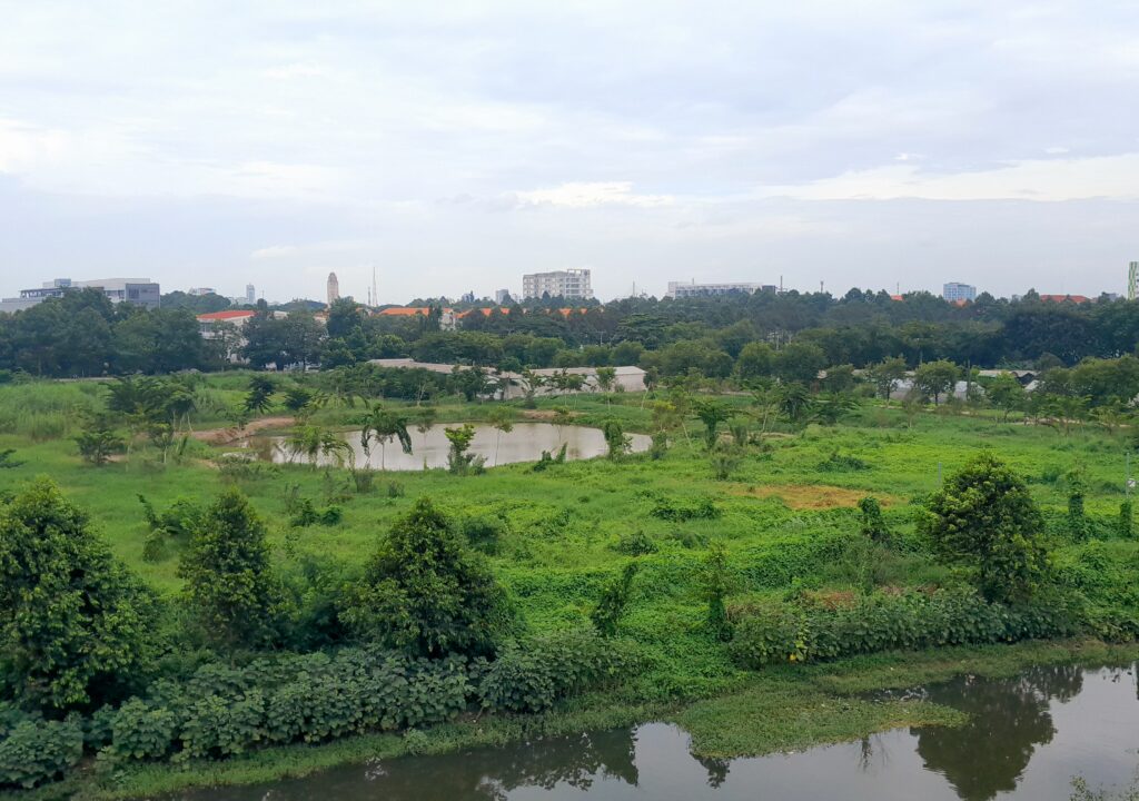
Illustration: Park in September 2024 with Lake Bung Xang in the foreground (Image: Jaakko Heinonen).
Reference to this article
Heinonen, J. & Carroll, P. 2026. Creating a floodable park as a solution to stormwater floods in Can Tho University Campus. LAB Pro. Cited and date of citation. Available at https://www.labopen.fi/en/lab-pro/creating-a-floodable-park-as-a-solution-to-stormwater-floods-in-can-tho-university-campus/